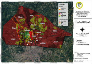
Hazard Map
A hazard map is used to identify and illustrate areas at risk from natural or man-made hazards, such as earthquakes, floods, landslides, or industrial accidents. The main purposes of a hazard map include:
- Risk Assessment: It helps in evaluating the potential risks and impacts associated with various hazards in different areas.
- Planning and Preparedness: By visualizing hazard zones, authorities can plan and implement appropriate measures for disaster preparedness and response.
- Public Awareness: It informs the public about the hazards in their area, enabling them to take precautionary measures and make informed decisions.
- Mitigation Strategies: It assists in identifying vulnerable areas where mitigation efforts, such as building codes or land-use planning, should be focused to reduce risk.
- Emergency Response: During a disaster, hazard maps help emergency responders prioritize resources and plan evacuation routes effectively.
Overall, hazard maps are crucial for reducing vulnerability and enhancing resilience to disasters.
Click download button on this page to get the complete document...
File Type:
pdf
Categories:
Maps
Language:
English