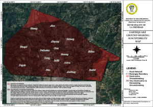
Earthquake Ground Shaking Susceptibility Map
An Earthquake Ground Shaking Susceptibility Map is a type of map that shows the areas most likely to experience significant ground shaking during an earthquake. These maps are essential for understanding and mitigating the risks associated with earthquakes, as they help identify regions that might suffer more severe damage. Here are the key components and uses of such a map:
- Hazard Identification: The map highlights areas with varying levels of susceptibility to ground shaking. This is based on geological and seismological data, including soil type, bedrock composition, and historical earthquake activity.
- Risk Assessment: By showing the potential intensity of ground shaking, these maps assist in assessing the risk to buildings, infrastructure, and populations. Areas with softer soils, for instance, may experience more intense shaking than areas with bedrock.
- Urban Planning and Building Codes: These maps are crucial for urban planners and engineers. They guide the development of building codes and construction practices that ensure structures can withstand expected levels of shaking. This is especially important in earthquake-prone regions.
- Emergency Preparedness and Response: Authorities use these maps to develop emergency preparedness and response plans. Knowing which areas are most susceptible allows for better resource allocation and evacuation planning in the event of an earthquake.
- Insurance and Risk Management: Insurance companies use these maps to determine premiums and coverage areas for earthquake insurance. High-risk areas might have higher premiums due to the increased likelihood of significant damage.
- Public Awareness and Education: These maps also serve to inform the public about the earthquake risks in their area, encouraging individuals and communities to take proactive measures to reduce potential harm.
The creation of an Earthquake Ground Shaking Susceptibility Map involves the integration of various data sources, including:
- Seismic Hazard Models: These models predict the likelihood of different levels of ground shaking based on the seismic activity in the region.
- Geological Surveys: Information about the soil and rock composition is used to understand how different materials amplify or dampen seismic waves.
- Historical Earthquake Data: Past earthquake records help identify patterns and potential future risks.
Overall, these maps are a vital tool in earthquake risk mitigation, helping to protect lives and property through informed planning and preparedness.
Click download button on this page to get the complete document...
File Type:
pdf
Categories:
Maps
Language:
English