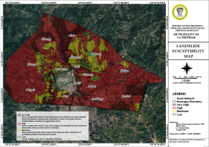
Landslide Susceptibility Map
This landslide susceptibility map serves to identify areas that are at risk of experiencing landslides. This maps helps in several ways:
- Risk Assessment: They provide information on which areas are more likely to experience landslides based on various factors such as topography, soil type, vegetation, and human activities.
- Land Use Planning: They aid in making informed decisions about land use and development by highlighting zones where construction or other activities might be risky.
- Disaster Preparedness: They help in planning for emergency response and mitigation measures by pinpointing high-risk areas.
- Resource Management: They assist in managing natural resources and maintaining ecological balance by identifying vulnerable areas that need special attention.
- Public Awareness: They increase public awareness about landslide risks and help in educating communities on how to mitigate these risks.
Click download button on this page to get the complete document...
File Type:
pdf
Categories:
Maps