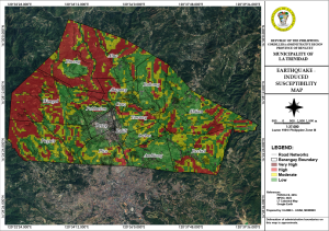
Earthquake Induced Susceptibility Map
An Earthquake Induced Susceptibility Map is a specialized tool used to identify areas that are more prone to experiencing severe impacts during an earthquake. These maps are created using geological, seismological, and engineering data to assess the vulnerability of different regions to earthquake-induced hazards. The primary components of such maps typically include:
- Seismic Hazard Assessment: This involves analyzing the likelihood of earthquake occurrences, their magnitudes, and the resulting ground shaking intensity in different regions. Historical earthquake data and fault line studies are often used.
- Soil and Rock Conditions: The type and condition of the soil and underlying rock layers play a significant role in how earthquake waves are amplified or dampened. Soft soils, for example, can amplify shaking, while harder rocks might reduce it.
- Topographic Features: Hills, valleys, and other topographic features can influence the severity of shaking and potential landslides. Steep slopes and loose materials are particularly susceptible to landslides triggered by earthquakes.
- Liquefaction Potential: In areas with loose, water-saturated soils, the shaking can cause the ground to behave like a liquid, leading to significant ground deformation and damage. Maps identify regions where liquefaction is more likely to occur.
- Infrastructure and Building Vulnerability: The type, age, and condition of buildings and infrastructure are considered to assess potential damage. Older buildings not built to modern earthquake standards are typically more vulnerable.
- Secondary Hazards: These maps may also consider secondary hazards like tsunamis, landslides, and fires that can be triggered by an earthquake.
Overall, Earthquake Induced Susceptibility Maps are used by urban planners, engineers, emergency response teams, and policymakers to design safer structures, develop disaster response strategies, and guide land-use planning to minimize risk and enhance public safety.
Click download button on this page to get the complete document...
File Type:
pdf
Categories:
Maps
Language:
English